Monday
Jan072013
Awesome! 2013 IGS calendar features LiDAR dataset of East Fork of the White River
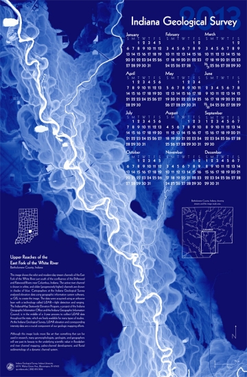
The folks at the Indiana Geological Survey are always pushing forward. This year's calendar shows the relict and modern-day stream channels of the East Fork of the White River just south of the confluence of the Driftwood and Flatwood Rivers near Columbus, Indiana. Cartographers at the Indiana Geological Survey analyzed elevation data using geographic information system software, or GIS, to create the image. The data were acquired using an airborne laser with a technology called LiDAR—light detection and ranging. At the Indiana Geological Survey, LiDAR elevation and corresponding intensity data are a crucial component of our geologic mapping efforts.
see it at: http://igs.indiana.edu/bookstore/details.cfm?ItemID=2160&Pub_Num=CAL2013
tagged  Fun, hydrology, imagery, remote sensing in Hydrology
Hydrology